
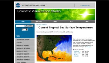

Pix: NASA’s Live Tropical Sea Surface Temperatures
Scientists draw information or forecast about ocean currents, climate, climate change and how a hurricane may evolve, from sea surface temperatures, with the help of satellite-monitoring. But, now, NASA has come up with a web page providing frequent updates on changing ocean temperatures.

Pix: 10-Day SST Showing El Nino Conditions
The result of data from the Advanced Microwave Scanning Radiometer (AMSR-E) instrument that flies aboard the Aqua satellite of NASA are presented in graphics in the webpage.